Have your say
The design survey is now closed.
Thank you for your feedback, your responses will be taken into consideration as part of the design. Please check back as additional consultation surveys will be released in future.

The design survey is now closed.
Thank you for your feedback, your responses will be taken into consideration as part of the design. Please check back as additional consultation surveys will be released in future.
Search for an address or zoom in and click on subway stations
We will be in the community, to understand the needs of local residents and businesses.
Closest station: Queen
Walking time: 0 mins
Website: https://shops.cadillacfairview.com/toronto-eaton-centre.html
Closest station: Union via Queen Station
Walking time: 9 mins
Closest station: Union via Queen Station
Walking time: 6 mins
Website: https://www.scotiabankarena.com/
Closest station: Osgoode
Walking time: 1 min
Website: https://www.coc.ca/venue-information/fourseasonscentre
Closest station: University
Walking time: 4 min
Website: https://www.mirvish.com/visit/theatres/royal-alexandra-theatre
Closest station: Science Centre
Walking time: 22 min
Website: https://torontobotanicalgarden.ca/get-gardening/public-gardens/edwards-gardens/
Exhibition Station serves one of the most popular destinations for sports, concerts, and trade shows in the country, not to mention family attractions like the CNE. The Ontario Line at Exhibition Station will create a connection to the GO network and bring the subway system closer to many homes and businesses in the growing and vibrant Liberty Village community.
Stats and Facts*
12,100 people within walking distance to station
12,100 customers will use the station during the busiest travel hour (8,400 getting on and 3,700 getting off the Ontario Line)
6,300 transfers during the busiest travel hour
17,600 jobs in the area
*Forecast for the year 2041
In the heart of Toronto’s Fashion District, where almost 8,700 households currently don’t own a car, the station at King and Bathurst will offer vital connections between the Ontario Line and the popular 504 King route and the 511 Bathurst route. Station entrances have been placed only a few steps away from streetcar stops on both the north and south corners of the intersection, allowing Ontario Line customers to walk from their subway platform directly to their preferred streetcar stop without having to cross the street.
Stats and Facts*
27,000 people within walking distance to station
5,100 customers will use the station during the busiest travel hour (3,000 getting on and 2,100 getting off the Ontario Line)
2,400 transfers during the busiest travel hour
24,200 jobs in the area
*Forecast for the year 2041
The station at Queen and Spadina will provide better access to the more than 42,200 jobs the area will accommodate by 2041.
Easy access to the Ontario Line will relieve crowding on the popular 501 Queen and 510 Spadina streetcar routes, with almost 3,800 streetcar riders transferring to and from the Ontario Line every day during the busiest travel hour.
Station entrances have been placed only a few steps away from streetcar stops on both the northeast and southwest corners of the intersection, allowing Ontario Line customers to walk from the subway platform directly to their preferred streetcar stop without having to cross the street.
Stats and Facts*
22,800 people in walking distance to the station
7,200 customers will use the station during the busiest travel hour (2,300 getting on and 4,900 getting off the Ontario Line)
3,800 transfers during the busiest travel hour
42,200 jobs in the area
*Forecast for the year 2041
The Ontario Line will link directly to Line 1 at Osgoode Station, giving customers an important connection to and from the existing subway network.
New station entrances on the northeast and southwest corners of the University Avenue and Queen Street intersection will create needed capacity for an increasing number of subway customers. They’ll also make it easy for customers coming from underground to get to directly to eastbound or westbound streetcar stops without having to cross the wide and busy intersection.
Stats and Facts*
16,500 people within walking distance to station
12,000 customers will use the station during the busiest travel hour (3,000 getting on and 9,000 getting off the Ontario Line)
5,700 Line 1 transfers during the busiest travel hour
1,000 surface transfers during the busiest travel hour
110,500 jobs in the area
*Forecast for the year 2041
Located in one of the city’s top spots for work, shopping and entertainment, the Ontario Line will provide a vital transfer point with Line 1 at Queen Station, allowing customers to seamlessly transfer between the two lines to get to the heart of the city and beyond.
With seven entry points to this important transfer hub in the city’s downtown core, about 16,600 people are expected to use Queen Station during the busiest travel hour.
Stats and Facts*
18,400 people within walking distance to station
16,600 customers will use the station during the busiest travel hour (4,500 getting on and 12,100 getting off the Ontario Line)
6,100 Line 1 transfers during the busiest travel hour
600 surface transfers during the busiest travel hour
150,000 jobs in the area
*Forecast for the year 2041
A new Ontario Line connection here will help relieve congestion on popular surface routes, like the 75 Sherbourne bus and 501 Queen streetcar, with almost 1,500 customers transferring to and from the Ontario Line every day during the busiest travel hour.
Students attending the George Brown College St. James Campus will have two choices for boarding the Ontario Line – a station in the area of Moss Park or a station in the neighbouring area of Corktown.
After construction, the park area will be restored and returned to the city for programming or redevelopment.
Stats and Facts*
23,600 people within walking distance to station
7,300 customers will use the station during the busiest travel hour (2,500 getting on and 4,800 getting off the Ontario Line)
1,500 surface transfers during the busiest travel hour
23,200 jobs in the area
*Forecast for the year 2041
The Ontario Line station serving Corktown will make it easier for people to visit this new and growing neighborhood and the nearby Distillery District.
A new Ontario Line connection here will connect to popular surface routes such as the 504 King Streetcar, 65 Parliament bus and 172 Cherry Street bus.
Corktown Station will be located next to the site of Upper Canada’s first Parliament Buildings.
Indigenous Peoples were present on the lands where the First Parliament site was built long before settlers arrived. The site is located on the traditional territory of many Nations, including the Anishnabeg, the Haudenosaunee and the Wendat Peoples. It is on lands covered by Treaty 13 with the Mississaugas of the Credit First Nation.
Stats and Facts*
26,400 people within walking distance to station
4,100 customers will use the station during the busiest travel hour (2,800 getting on and 1,300 getting off the Ontario Line)
1,900 surface transfers during the busiest travel hour
15,700 jobs in the area
*Forecast for the year 2041
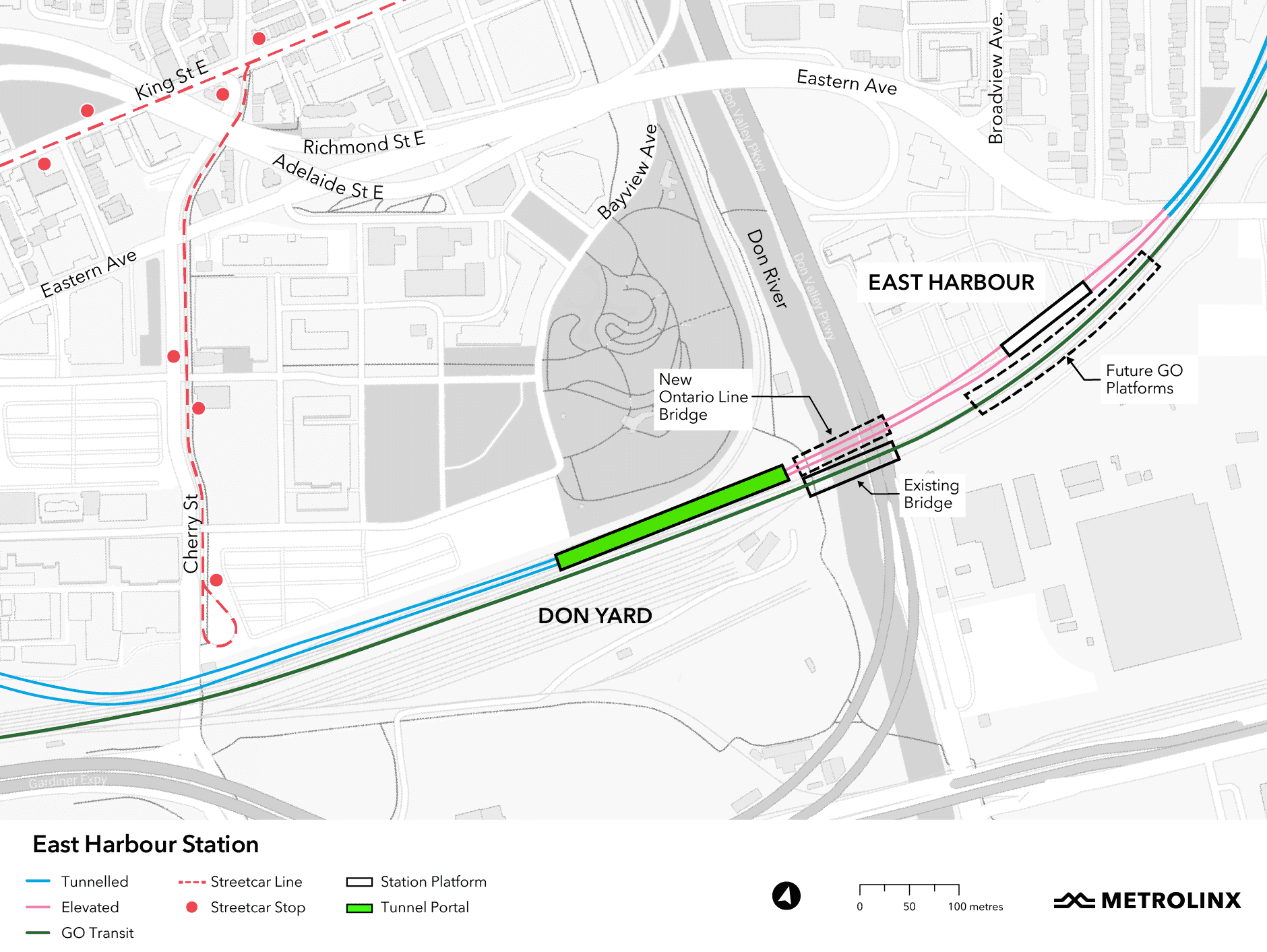
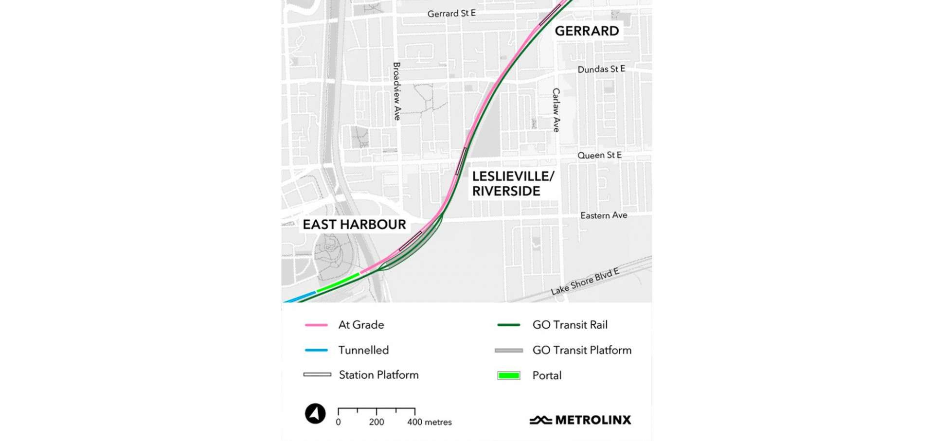
Just east of the Don River and north of Lake Shore Boulevard East, a station at East Harbour will be an important transfer point, accommodating GO operations, a planned extension of the Broadview streetcar, and Ontario Line service in a corner of the city that is poised for growth.
The future East Harbour transit hub will be a vital connection for customers transferring between the Ontario Line and GO train services, helping to reduce crowding at Union Station by up to 14 per cent – or 14,000 people - during the busiest travel hour. With a shared concourse providing easy access to all the rail services that will serve East Harbour, more customers will be able to transfer from the GO train to the subway network and travel to more places.
Stats and Facts*
5,800 people within walking distance to the station
8,600 transfers during the busiest travel hour
14,900 people will use the station during the busiest travel hour (7,000 getting on and 7,800 getting off the Ontario Line)
50,000+ jobs in the area**
*Forecast for the year 2041
**According to Transit-Oriented Communities proposal for East Harbour.
Located in one of the city’s most distinct spots for one-of-a-kind shopping, an estimated 4,000 people are expected to use the station at Leslieville during the busiest travel hour, with roughly 2,800 transferring to and from the busy TTC streetcars serving the area.
This station will also make it easier to access important community spaces like McCleary Playground, Bruce Mackey Park, and Jimmie Simpson Park and its recreation centre.
Stats and Facts*
9,500 people within walking distance to the station
2,800 transfers during the busiest travel hour
4,000 people will use the station during the busiest travel hour (2,500 getting on and 1,500 getting off the Ontario Line)
6,900 jobs in the area
For more information on Ontario Line construction in your community click here.
*Forecast for the year 2041
The future Ontario Line station at Gerrard will provide easy transfers to both streetcar and bus routes just steps from station entrances.
An estimated 3,300 people are expected to use Gerrard station during the busiest travel hour, with 2,000 transferring between the Ontario Line and local streetcars and buses. This will make travelling especially easy for the 1,100 households in the area that don’t currently own a car.
Stats and Facts*
11,900 people within walking distance to the station
2,000 transfers during the busiest travel hour
3,300 people will use the station during the busiest travel hour (2,400 getting on and 900 people getting off the Ontario Line)
3,800 jobs in the area
For more information on Ontario Line construction in your community click here.
*Forecast for the year 2041
Pape Station will make it easier to get to the vibrant Greektown neighbourhood and its many restaurants, shops and markets. Experiencing the rich culture and hospitality along the Danforth will be more convenient than ever thanks to the connection to Line 2. The station will be within a short 10-minute walk for 12,700 residents and connect people to the 3,700 jobs the area will support by 2041.
By positioning the Ontario Line station out of the street and straddling Line 2, impacts to area traffic during construction will be reduced and customers will have smoother transfers between the lines once the Ontario Line is up and running.
Stats and Facts*
12,700 people within walking distance to the station
9,100 transfers during the busiest travel hour
10,200 customers will use the station during the busiest travel hour (7,500 getting on and 2,700 getting off the Ontario Line)
3,700 jobs in the area
*Forecast for the year 2041
The Ontario Line will bring customers to Pape Village and East York thanks to a new station at Cosburn and Pape. A total of 10,300 people will be within a short 10-minute walk of the station by 2041.
By positioning Cosburn Station west of the street, fewer utilities will need to be relocated, including the recently upgraded water main.
Stats and Facts*
10,300 people within walking distance to the station
1,200 transfers during the busiest travel hour
2,600 customers will use the station during the busiest travel hour (2,200 getting on and 400 getting off the Ontario Line)
1,300 jobs in the area
*Forecast for the year 2041
After crossing the Don Valley, the Ontario Line will cross Millwood Road and run along the north side of Overlea Boulevard on an elevated guideway that will be designed to fit nicely with its surroundings and create opportunities for new public space underneath. This is possible because of the wider street layout, and it avoids the need for disruptive tunnelling activities. Metrolinx will seek community input on designs as part of ongoing consultations.
The station located at Thorncliffe Park Drive brings higher-order transit (transit that runs outside of mixed traffic) to a community that has been historically underserved by transit. The station and the elevated tracks will be completely separated from vehicles and pedestrians to provide reliable, safe service. An estimated 12,800 people will be to walk to Thorncliffe Park Station in 10 minutes or less by 2041. The new station will also bring people closer to roughly 3,000 jobs in the area.
Stats and Facts*
12,800 people within walking distance to the station
500 transfers during the busiest travel hour
3,100 customers will use the station during the busiest travel hour (2,100 getting on and 1,100 getting off the Ontario Line)
3,000 jobs in the area
*Forecast for the year 2041
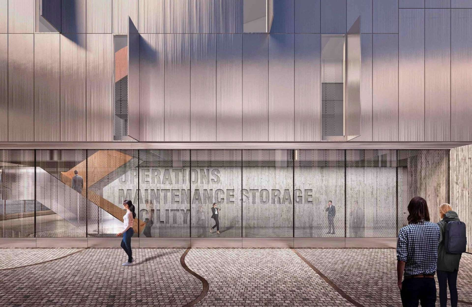
The maintenance and storage facility is a vital organ of any public transit operation. It’s where trains will be housed, maintained, and serviced each day to keep them clean and safe for our customers.
An estimated 44 trains will be needed to meet Toronto’s needs when the Ontario Line opens, and the fleet will grow by as many as 10 more vehicles to meet demand for service in the future. We needed a large site with the right land configuration to support that growth. After extensive study, a site in the southeast portion of the Leaside Business Park was selected because our studies showed that it met all of the technical needs for the project with the fewest impacts to jobs, businesses and local organizations.
The maintenance and storage facility will also bring upwards of 300 new jobs to the community once the Ontario Line is in service.
The station in Flemingdon Park will be located on the west side of Don Mills just north of Gateway Boulevard.
This station will help meet an already significant demand for transit in the neighbourhood it serves. The 25 Don Mills bus route that serves the Flemingdon Park area is today the seventh most-used bus line in Toronto – an estimated 28,900 TTC riders take this bus every weekday to get where they need to go.
Stats and Facts*
9,700 people within walking distance to the station
2,800 customers will use the station during the busiest travel hour (1,700 getting on and 1,100 getting off the Ontario Line)
100 transfers during the busiest travel hour
2,600 jobs in the area
*Forecast for the year 2041
A new transit hub at the Science Centre Station will connect the Ontario Line to the Eglinton Crosstown LRT and frequent local and express bus services from the north.
The station will be elevated and located at the northeast side of Don Mills Road.
Customers will be able to access both the Eglinton Crosstown and the Ontario Line from entrances at both the southwest and northeast corners of Don Mills & Eglinton.
Underground passages will provide an alternative to crossing the intersection at street level.
For customers transferring from the Ontario Line to the Eglinton Crosstown, escalators and elevators will provide accessible, indoor connections between the two lines as well as access to the bus terminal.
Stats and Facts*
8,000 people within walking distance to station
5,800 customers will use the station during the busiest travel hour (3,600 getting on and 2,200 getting off the Ontario Line)
3,600 transfers to/from the Eglinton Crosstown LRT during the busiest travel hour, and 1,400 from local buses
9,200 jobs in the area
*Forecast for the year 2041
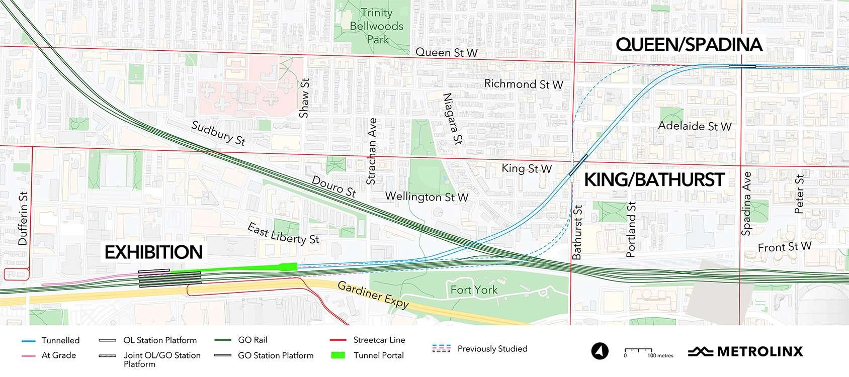
We are making important progress on bringing more rapid transit to downtown Toronto with the Ontario Line. Stations in the west segment at Exhibition, King/Bathurst and Queen/Spadina will make it easier to access some of the City of Toronto’s top spots for sports, entertainment, shopping and so much more. Stations will relieve crowding on popular surface routes through the downtown core and make transferring between services a breeze.
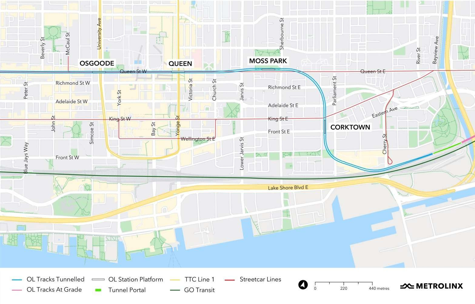
We are making important progress on bringing more rapid transit to downtown Toronto with the Ontario Line. The stations at Osgoode, Queen, Moss Park and Corktown will give people fast and easy connections between the Ontario Line and other major transit routes. The stations have been designed to put customers close to popular streetcar and subway routes and to develop a truly integrated transit network, making it as simple as possible to experience the city and the whole Greater Golden Horseshoe all with the simple tap of a PRESTO card. This will help spread demand across the existing network and make it easier for people to choose transit first.
In this segment of the Ontario Line, trains will run in the existing GO rail corridor, which Metrolinx already owns.
Building the Ontario Line within Metrolinx property will cut down on construction timelines and impacts to neighbouring properties. Ontario Line work will be streamlined with GO expansion work that was already planned for the corridor, reducing the number of construction zones and related impacts in the surrounding communities.
Ontario Line stations in this area will provide excellent connections to other surface transit, including GO train services at East Harbour and TTC streetcar and bus services throughout Riverside and Leslieville.
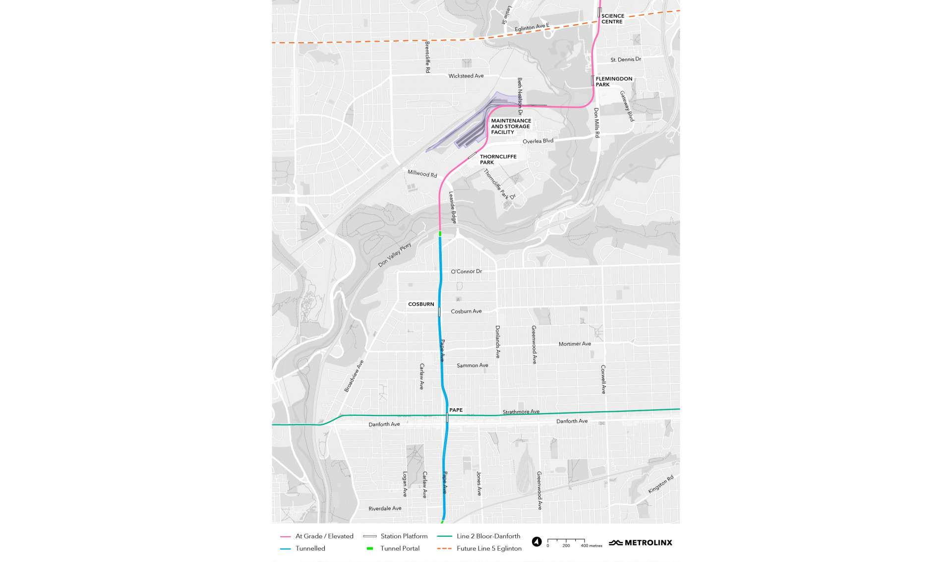
The maintenance and storage facility – which will be located in Thorncliffe Park - will bring upwards of 300 new jobs to the community once the Ontario Line is in service.
All impacts are subject to further discussions between Metrolinx, the City of Toronto, the TTC and future project partners.
For more information on Ontario Line construction in your community click here.
All impacts are subject to further discussions between Metrolinx, the City of Toronto, the TTC and future project partners.
For more information on Ontario Line construction in your community click here.
All impacts are subject to further discussions between Metrolinx, the City of Toronto, the TTC and future project partners.
For more information on Ontario Line construction in your community click here.
All impacts are subject to further discussions between Metrolinx, the City of Toronto, the TTC and future project partners.
For more information on Ontario Line construction in your community click here.
For more information on Ontario Line construction in your community click here.

Metrolinx will be hosting a design competition to come up with creative design solutions for elements of the Ontario Line project in Riverside and Leslieville that represent the community’s vision for the area.
Before the competition starts, Metrolinx will be hosting multiple opportunities for community members to provide feedback on what they would like to see in future designs. The feedback will be shared with design competition participants to help guide their submissions.
Click here to complete the design competition survey.


For more information on Ontario Line construction in your community click here.
All schedules are estimates and subject to change.


